Bureau of Agricultural and Fisheries Engineering (BAFE)
Geographic Information System for Agricultural and Fisheries Machinery and Infrastructure (GEOAGRI)
GEOAGRI is an interactive web mapping application that displays information on Farm-to-Market Roads (FMR) projects. It includes information on Agri-fisheries Machinery and Rural Infrastructure Projects, such as irrigation, post-harvest facility, fisheries facility, livestock facilities and renewable energy, among others.
About GEOAGRI
GEOAGRI is an in-house web-based system jointly developed by the Bureau of Agricultural and Fisheries Engineering and Caraga State University to consolidate the information of FMR projects. It is envisioned to be the common portal for all Government Agencies and Local Government Unit (LGU) implementing FMR which promotes transparency, governance, maximized resource allocation and minimized duplication and overlapping of projects.

GEOAGRI Objectives
- GEOAGRI aims to provide an online interactive Management Informative System(MIS) portal which will consolidate, store/manage, process, and analyze GIS-based data of the FARM-to-Market Road Projects of the Department and other road projects of National Government Agencies(NGAs) and Local Government Units (LGUs).
- Provide an avenue for transparency, inter-agency data sharing, science-based approach planning, and harmonization of FMR implementation.
- Facilitate the visualization of robust spatial data available online and provides a visual assessment of the road network.
- Address the issues on FMR location where farmers will fully utilize the benefits, interconnectivity of FMRs, elimination any form of duplication, and build FMR information system among the different implementing agencies and complement NAMRIA geoportal and other online web-mapping data sources.

Services
GEOAGRI is an enhanced IROAD that provides additional functionalities that includes reports generation, specific user-dashboard, enhanced GUI for user ease-of-use, and API functions for other supporting agencies. It is used to automate the prioritization of proposed FMR based on set criteria. It provides and interactive geo-mapping visualization of roads and its connectivity.

Data Management
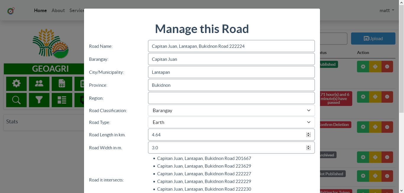
GEOAGRI manages multiple information such as user data, GIS files, and other related to the different projects. GEOAGRI pulls existing data from the Agricultural and Biosystems Engineering Management Information System (ABEMIS) of BAFE to display the location of all distributed pieces of machinery and completed infrastructure projects. User registration, request, and grievances are managed and evaluated by the admins.
Public Map
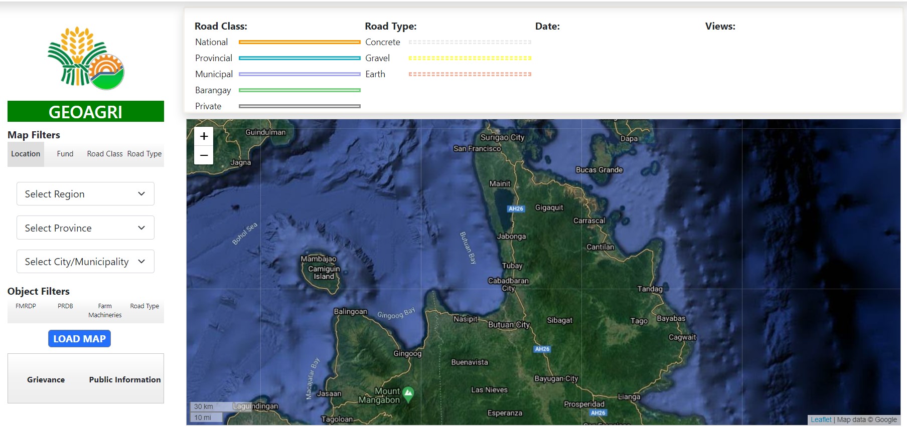
The Public Dashboard page enables access to public reports and map views. The page is for public transparency and displays different agencies’ activities. The map filters contain the different filters such as By Location, Source, Road Class, and Road Type.
Grievance and Requests
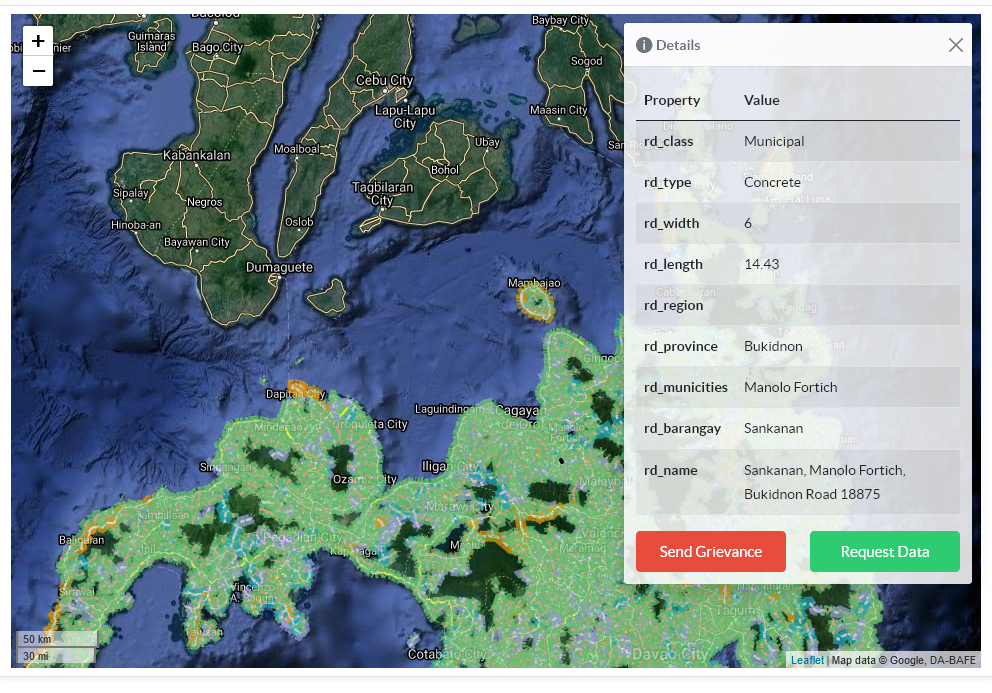
GEOAGRI provides an interface for grievances and data requests. Road marks enable the users to specify the project of the grievance complaint. The user’s data request will require inputs and a request. All these actions will be evaluated by the admins.


info@da.gov.ph
+63 (2) 8928-8741 to 64 and +63 (2) 8273-2474
Elliptical Road, Diliman, Quezon City, 1100